Monday, August 30, 2010

10 Orchard Lane

and how we fell in with the perfect situation

Our friends Michele and Tim built this truly sweet cabin on the land that has been in Michele's family for 3 generations.
As perfect synchronicity would have it, we were looking to move to the northern west, and they were in need of people to finish the cabin... voilá!
here we are in lovely little Willow Creek California.


our first night in the cabin!


Josh soon put in a kitchen sink


and prepared the soil for a garden with oyster shells and chicken manure. mmmm.


we ate salmon out on the porch...


took some hammock time


sealed the decks and the eaves...

made the cabin warm with a wood-burning stove...


and watched our garden grow.


Saturday, August 7, 2010

the SMITH river

This river - turquoise blue - is one of the most beautiful (if not in fact, the most beautiful) river I have ever seen. It is so crystal clear because of the serpentine or peridotite in the rock and because the rock itself is granite - so there is little sediment to cloud the water.


The Smith has wild and scenic status because it has no dam blocking it's natural flow. It is also supposed to have one of the largest populations of Steelhead. They are a type of trout that hatch in the river, swim to the ocean and return to the river to spawn - meaning they are anadromous fish - like the Salmon and Sturgeon. Abby Imsand Nielson is afraid of Sturgeon because they are like large, prehistoric monsters.

We drove up the river corridor as far as Cave Junction, Oregon, and then back down to camp near the smaller North Fork of the Smith.

This might be a bit of a challenge, but if you look very carefully, there is something up in this tree - quite near the top in fact.


Did you spot him?


Here's our cozy little camp - replete with puppy dog and minivan. I think at this point I am lounging in the tent because it is what we termed "red hour" - the time when the mosquitoes come out to play.


We stayed a couple of days by the Smith, hiking around and relaxing before we decided to head back toward Humboldt County. Seems I put the camera away for a while, because we didn't document our stint by the Mad River in a lovely spot named 'swinging bridge.' The old bridge is no longer but there's still a huge rope swing that I remember lobbing myself off of when I was in college.
...and even though it was cold, Josh took the challenge, launching himself off the cliff hanging on to the 40' rope swing and let fly into the water. Very fun...!


next we go to meet Tim, Michele and Ula on the South Fork of the Trinity at Surprise Creek.

Friday, August 6, 2010

there's climbing on them thar rocks

flint rock and gold beach 8/6/2010


(picture taken through Josh's monocle)

Heading back to the coast from Hell's Gate, our trusty Subaru began to buck and stutter like a frolicking goat. So we dropped it off in Eureka (land of many auto mechanics) to have it almost entirely overhauled, and rented a super cool white Town & Country minivan. We had the guy at the Enterprise rental take all of the seats out of the back, and we were off riding in style.

We decided to do both town and country beginning with free camping in Prairie Creek State Park. In this "primitive" site we were in heaven - floating in the misty cloud forest near the bluffs over the wild, wild ocean. From our vantage from the bluff we saw distant whales blowing as they migrated south. That's what we were trying to capture in the monocle. :)

We had also heard that there was climbering below, and sure enough...


...there she was. All ready to take on any intrepid or foolhardy soul.


like Josh for example.


except that he wasn't really sure of the salted bolts. They looked like they had been subjected to the cold ocean water splash of the waves for a good many years.


These here are salt crystals. Proving that we are indeed next to a large body of salty water. Over time, the evaporating water left a large residue of salt on the bottom of this small rock indentation. There is also a mysterious visage of a visor-wearing man.


(I really don't know what that orange thingy is.)


...and then Gold Beach had something really superb to offer.


These monolithic stones rising out of the low clouds. They were inviting - nice firm rock to hold, and if not - soft sand to land on.


Like a big toothy rock mouth.. look out Malia!!!!!


watching Josh climb sends me all into a tizzy...


wheeeeeee!


next: the SMITH river ;)

Thursday, August 5, 2010

Hell Gate camp on the South Fork of the Trinity River


August
3,4 & 5
2010


It was windy and cold on the coast at the Mattole river, and we wanted to warm our mostly fur-less and soft bellied bodies in the sun, so the decision was made to head inland a bit.


We drove up hwy 36 along the Van Duzen river to see what we could see. Through the redwoods and up into the grassy hills and dry, piney forests.

We're still not sure why someone decided to call this area Hell Gate. It's really very pleasant.


We had coaxed Solo into the pond near our house on some very hot days in Colorado before we left on this journey. It took a lot of cajoling - he really wasn't inclined to even get his feet wet. He didn't seem to have any instinct to get in water - on the contrary, I think he knew to stay away from the wet stuff. One day the stick that he really, really wanted was tossed a little farther into the pond, and he was suddenly swimming to get it.
And now here we are, in river country - Solo is beginning to make this a part of his daily love of life. It's so thrilling to watch him swim... every time!

SoLo really didn't like this swinging bridge thingy.


The South Fork of the Trinity River National Recreation Trail begins at Hell's Gate campground and goes about 21 miles upstream skirting the river the whole way. We walked a bit of it and found some great swimming holes.


Our pace of life had slowed way down and we could sit for hours and check out the daily meanderings of the caddisfly. It made me remember the artist Hubert Duprat for his collaborations with the little creatures that will make their protective coverings out of whatever is readily available.

Like gold and pearls.


meanwhile back at camp...


...while our sweet potatoes cooked on the fire,

we used up some of that endless time of ours scraping every last bit of strawberry jam out of the little jar Carah had sent Josh for his birthday.


I employed every means available to me.


thanks, Carah. yum.


next posting: Flint Rock

Monday, August 2, 2010

...and still further west!

July 31 - August 2nd, 2010

thick fog
the waves dissolve
into distant roar
After leaving mom's house in Lake Tahoe we made our way through northeastern California. (The part about moving our stuff into storage in Weaverville's 100 degree weather is only worth mentioning briefly here, it wasn't really a pretty scene - we both felt muddled and dizzy from the intense heat!) So we dropped off the uhaul - goodbye crane! - and continued westward. We had 10 days before moving into Michele and Tim's cabin and decided to get to know the place a bit by camping in as many beautiful spots we could find.
Down Highway 101, we cut further west through Ferndale, a small Victorian dairy farming town, and took a quick left onto the tiny winding road that led to the northern-most point of what is called the Lost Coast. It's scantly populated with vast rugged ranch land (probably rugged cows as well.) Initially we were shrouded in fog and but quickly the clouds lifted, and soon we were able to see the ocean.


the Mattole sliding in next to the ocean...


The Mattole river slowly seeps through the sand, gently sifting into the Pacific and causing the beach to slough and erode in really beautiful patterns.
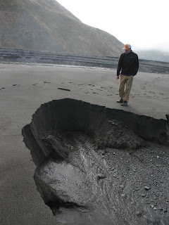


...soLo making tracks around a slip


diving board


We hiked a couple of miles down the beach from our campsite on the beginning of the 25 mile trail that heads south all the way to Shelter Cove in Mendocino county. It's so steep that the road builders decided to avoid it when they built
Hwy 1. Oh, and did I mention earthquakes? We were camped on the Mendocino Triple Junction, where three fault lines meet!

Josh came across seals and sea lions lined up neatly along the beach, warming themselves in the sun (I wish I had remembered the camera.) And then we reached the Punta Gorda lighthouse.

There's the lighthouse on the right side of the picture...
This is an old picture - those houses aren't there anymore. The story is that when the Bureau of Land Management took over this area, they burned the houses down in the 1950's to keep the hippies from living there.
This place and the houses that used to surround it was built from materials that were ferried up the ocean and brought ashore by cables through the waves. Big waves!
Being on the Lost Coast was an amazing reintroduction to the Pacific Ocean - so wild and vast - truly awesome.

next installment: the rivers